|
NKAN PROJECT
Property Description
The Nkan project covers an area of Archean greenstone belts. The geology consists of a typical granite-greenstone assemblage of ultramafics (komatiites?), banded Iron Formations (BIF), granodiorite gneisses, and feldspathic quartzites cross cut by a series of N-NE trending shear zones.
Previous Work: During it's "Mission du Mitzic" the Bureau de Recherches de Géologiques et Miniére (BRGM) covered the whole area with an extensive stream sampling program. From this, a large gold stream gold anomaly, with values up to 85ppb in stream sediments and up to 420g/m3 in pan concentrates was found that appeared to have a close spacial relationship with the banded iron formations in the area.
Work Done: We aggressively followed up the BRGM results with a soil sampling and prospecting campaign. Since September 2007 over soil 3000 samples have been taken over four separate areas targeting gold. Three of the soil grids defined 3 separate coherant gold anomalies (>15ppb) with peak values above 50ppb. The Nkan 2 & 3 grids defined a N-NE trending gold anomaly over 20km in length within the BIF unit and is speculated to be associated with the similar trending shear zones in the area. Follow up on these anomalies has proven difficult however due to the very deep soil profile (>50m in places) in the Nkan region. Future work in the area will target these soil anomalies with an augering program (down to 10m), geophysics and results depending, drilling.
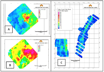
Above: Nkan 1 gold (A) and vanadium (B) results, and Nkan 2 &3 gold (C) results. The Nkan 2 &3 results define a gold anomaly >15ppb over a 20km strike length.
Summary
The geology of the Nkan project is composed of a typical Archean greenstone belt assemblage of ultramafics, banded iron formations, and granitic gneisses, rocks which are known to host some of the largest gold deposits in the world. The area has been crosscut by a series of large NNE trending shear zones which based on the soil geochemistry appear to be the structures hosting the gold found in the streams. The high prospectivity of the rocks coupled with the size of the structures in the region and underexplored nature of the Nkan area points to the potential in the region.
To view the complete Gold Projects Summary, please click here.
To view the Nkan Mineral Maps, please click here.
Website Copyright ©2010 Metalline Mining Company. All Rights Reserved.
|