|
LA MBOUMI PROJECT
Property Description
The La Mboumi project is located in one of Gabon's historical gold fields which has been completely enclosed by "Ndjole" exploration licence. The licence covers an area of metavolcanics and metasediments interpreted to be part of a neo-proterozoic volcanic arc system. The geology is composed of of mica and graphitic schists, quartzites, metapsammites and pelites that have been strongly deformed and metamorphosed up to greenschist facies. Numerous structural disruptions, some over 50km in strike length, associated with the continental scale Ikoye-Ikobe fault in the south also crosscut the area, and are thought to be the main conduits for the gold mineralization seen in the area.
The rivers in La Mboumi region and are generally small and low energy, yet yield "angluar" gold nuggets up to 3oz in size indicating the source of the gold is likely to be from a primary source very close by. This combined with the wide spread nature of the artiznal workings also suggests that the mineralization occurs over a broad area.
Previous Work: During its "Mission du Monts de Cristal" the BRGM targeted the La Mboumi region taking over 5000 stream samples, from which they identified 25 gold and basemetal anomalies. One these anomalies was followed up by a United Nations Development Program with soil geochemistry. The resulting gold target was then drilled by the Gabonese Geological Survey equivalent (The DGRM). The Drill logs from this program show all of the 7 holes drilled intercepted gold mineralization, with the best results coming from 4 of the holes being; 3.5 g/t over 10m, 1 g/t over 14.5m, 2.3g/t over 6.5m, and 1g/t over 9m.
Work Done: Work in the La Mboumi region has aggressively followed up the DGRM drillholes with prospecting, soil geochemistry, and geophysics. Soil results show a series of strong coherant gold and arsenic anomlies with a distinctive NE-SW trend that coincides with major structures in the area. Peak values for gold in the soils exceed 900ppb (background values are <5ppb) and remain open to the south and the west. An electromagnetic and magnetic survey flown in July 2008 shows a strongly conductive, folded carbonaceous unit that extends through the property and coincides with the soil anomaly. The carbonaceous unit is thought to represent a favourable gold deposition site for the mineralization in the area and it appears that many of the artiznal workings in the area have a spacial association with this unit.
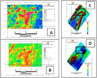
Above: La Mboumi soil grid with gold (A), copper (B), nickel (C), chrome (D). Also the EM (E) and Magnetic (F) survey with the soil grid location. The strong magnetic response is due to banded iron formations in the area. The orange dashed lines shows an inferred fault based from the magnetics that coincides with the EM anomaly.
Summary
The La Mboumi region has all the attributes typical for a major orogenic gold deposit; The proximity to a deep seated major fault structure and its associated 2nd and 3rd order splays -- some of which are over 50km in strike length , the metamorphic grade of the rocks (greenschist facies), and the presence of a reducing carbonaceous unit, coupled with the wide spread workings of orpialleurs, and economic gold values from drillholes (unconfirmed) indicates the potential of the area to host a world class deposit.
To view the complete Gold Projects Summary, please click here.
To view the La Mboumi Mineral Maps, please click here.
Website Copyright ©2010 Metalline Mining Company. All Rights Reserved.
|